Groundwork and Re-visioning in the Gateway Cities
Connecting ideas, sharing information, supporting ongoing work
Everything is connected, through watershed planning
In our rapidly changing world, we are challenged to ensure that all have access to clean water and air, infrastructure to ensure health and safety, and efficient movement of people and goods that supports businesses while enriching our lives. In dense urban areas, we are challenged to realize the many benefits we value within limited space and resources. To this end, our various municipalities and entities have invested in separate plans for transportation, for education, for culture, for health, for water, for economic development, and for sustainability. Many of these previous planning efforts are presented below.
From the scale of watersheds we can comprehensively consider many of these challenges facing us as integrally interconnected. Watershed planning is a way for us to think about these challenges together, creatively, and effectively. Watershed planning is not just about improving water quality in our rivers. It is about solving challenges by integrating nature-based systems into our everyday lives. Landscapes connect everyone, from the youngest to the oldest, from the most humble to the most proud, from residents to city managers, from students to organizations, from the ancestors who lived on this land to the communities of plants and wildlife that now make our local waterways, however tenuously, their home. Thus, tapping into the power of nature, even within the densely urban cities we call home, will be one key to our communities’ resilience in the face of future challenges.
A web-based watershed vision plan
In the past, the work of urban planners seemed to take place in a “black box”— where analysis and design were deemed the work of experts, these planning processes opaque and hidden to the public. Today, however, the process of stakeholder engagement in the early stages of developing built improvements in the urban environment is recognized as critical to the success of any project. Transparency enables communities to understand the implications of different decisions, and to weigh the pros and cons of alternative approaches.
Most importantly, when communities shape projects, they are more likely to continue as stewards of those spaces. Community participation is part of successful placemaking.
In this web-based format, this plan and guide aims to bridge the space between communities and the process of planning. Here, we address some of the challenges faced by our communities—education, economics, safety and security, public health—and introduce ways in which nature-based solutions can address these issues, alongside watershed health. This vision plan serves as both a platform for communication and toolkit to share and build on resources.
Example ‘Greenscapes’ suggest diverse approaches to watershed planning that can be adapted to suit local values and priorities on the scale of a single parcel. We show how even our densest and most urban places contribute to the whole watershed picture, even when they do not appear to be next to a riverbed. Understanding how everyday urban landscapes relate to overall watershed health allows communities to access existing resources to serve local needs. Improving watershed health also means improving community health.
This plan and toolkit aims to demonstrate how nature-based solutions can knit together this this seemingly diverse palette of approaches. Nature-based solutions not only complements centralized water management approaches, but also has potential to address climate change planning, housing, active transportation, public health, and economic development, and has economic advantages to municipalities as well.
The Gateway Cities and Rivers Guide to Urban Greening incorporates elements of a traditional planning study:
Inventory and Analysis
Data analysis (Existing conditions, soils, hydrology, demographics, health, economics)
Land use analysis identifying key land use typologies and opportunities
Opportunity sites acknowledge and build on existing plans that have been put forth in the Gateway Cities
Stakeholder input
This project has incorporated feedback described in A Collaborative Process, gathered from meetings with Gateway Cities Council of Governments (COG) and municipalities, Lower LA River and Lower San Gabriel River outreach events, Lower LA Revitalization Plan, 710 Liveability Plan workshops, and at local community events and group meetings.
Advisory Group feedback made up of local government and community group representatives listed under Acknowledgements.
Local Voices is also a showcase of some of the diverse voices, goals, aspirations, and perspectives of Gateway Cities writers who write about the places they have called home
Recommendations
Greenscapes re-visioning based on the key land use typologies of the Gateway Cities
Opportunity Sites identifies some high value multi-benefit opportunities specific to each city.
Green network includes spatial inventory and map data.
Stories of empowerment and tools for implementation
Community Projects tells just one story of how a group of students worked with some Gateway Cities communities to define how local green infrastructure could serve neighborhood priorities. The local design-build projects were organized by, and utilized the skills of participating community members, and resulted in community-centric neighborhood amenities, as well as planning for more ambitious long-term projects.
A future addition to this website will include a database that can help identify funding sources for multi-benefit green infrastructure projects.
This plan and toolkit is meant to empower communities by instigating dialogue, providing inspiration, providing knowledge of and connection to resources. Communities can use this toolkit to shape our shared urban landscapes with a vision of a shared future in a living watershed.
olmsted plan

grassii final greenway network

Tying existing plans together
Many concurrent planning efforts that include the Gateway Cities Region can be organized around the themes of Access (transportation), Parks and Open Space, and Water.
Historically, each of the Gateway Cities municipalities was founded on its own community vision, and incorporated specifically to gain control of local priorities and governance. The Gateway Cities Council of Governments (COG) was formed to accomplish regional planning goals. The Gateway Cities COG has organized around transportation planning, air quality, economic development, housing, watershed planning, and has developed a Climate Action Planning Framework.
Access and Transportation Plans
Gateway Cities COG/Metro ATP
Integrated Regional Water Management Plan (IRWMP) (2011)
Lower Los Angeles River Water Management Plan
LA County Step by Step pedestrian plans for unincorporated areas, including Walnut Park
710 Liveability Plan enhances pedestrian connectivity in about 30 locations along the 710
Los Angeles County Bicycle Master Plan (2012)
Water Management Plans
The Gateway Water Management Authority is an active intergovernmental coalition focused on water resources.
Gateway Integrated Regional Water Management Plan (IRWMP)
Lower Los Angeles River Watershed Management Program (WMP)
Lower San Gabriel River Watershed Management Program (WMP)
Rio Hondo/San Gabriel River Watershed Management Program (WMP)
Parks and Open Space Plans
Los Angeles County Park Needs Assessment (2016) offers inventory and documentation of existing parks and facilities, demographic, health, safety, and environmental community profiles, and took into account the feedback of more than 5,000 workshop participants. Community profiles and recommendations are available for download on the project website. Each community prioritized future projects, which included creating new parks, as well as improving amenities in existing parks.
Integrative plans
River and stream master plans have generally focused on trail and park and habitat opportunities in immediate proximity to the river. These plans have universally recognized that waterways are opportunities to solve access and connectivity needs, while also developing park and open space in our communities.
The Los Angeles River and its tributaries:
Los Angeles River Master Plan (1996, LA County)
Los Angeles River Revitalization Master Plan (2007, City of Los Angeles’ Ad Hoc Committee on the Los Angeles River
The Los Angeles River Ecosystem Restoration Feasibility Study (2016, USACE , Adapted by LA City Council in 2016)
Lower LA River Revitalization Plan (2018, LA County) focus of attention, outreach efforts span many realms including arts and culture. Greater understanding of the river will help expand the conversation beyond the river.
Los Angeles River Master Plan, (2020, LA County)
Compton Creek Regional Garden Park Master Plan
The San Gabriel River and its tributaries:
San Gabriel River Corridor Master Plan: A Common Thread rediscovered (2006, Los Angeles County DPW and DPR) addresses recreation, habitat, flood management, and open space for the San Gabriel River. Divides the SG River into 7 reaches each with different land use opportunities.
San Gabriel River Tributaries with Plans:
Coyote Creek Bikeway Master Plan
Coyote Creek Master Plan
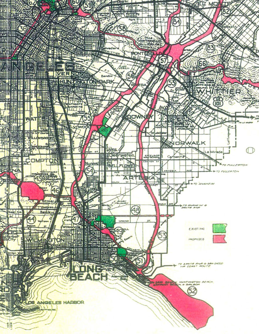
Olmsted Bartholomew Plan Integrated watershed planning is nothing new. Commissioned by the LA Chamber of Commerce, the Olmsted Bartholomew Plan (1930) proposed a regional network of parkways to link public beaches, athletic fields, schools, and larger reservations and parks. Park corridors would double as a flood basins to absorb stormwater during large storms. Frederick Law Olmsted Jr. considered parks a necessary part of public health infrastructure, and part of the region’s social and economic vitality. Olmsted recommend the creation of a regional centralized park agency to implement this large scale project. Though the Olmsted Bartholomew as forward thinking, it was not implemented. Yet, the Olmsted Bartholomew Plan continues to inspire integrative planning, and its influence is evidenced in the Emerald Necklace and the Green Visions Plan.
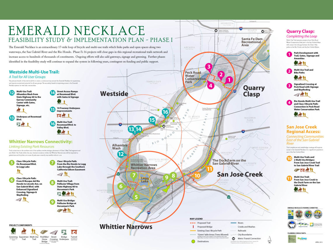
Emerald Necklace Forest to Ocean Expanded Vision Plan (2014) Amigos de los Rios revives elements of the Olmsted Bartholomew Plan, expanding the work of the Emerald Necklace Coalition beyond San Gabriel Valley into the Gateway Cities, to propose a continuous park and trail system from the mountains to the sea.
Data-driven planning and analysis
A proliferation of data-driven planning and analysis tools range from planning studies that gather and present data and community feedback and make specific planning recommendations; to data-driven decision support tools that can test our different scenarios supporting user priorities; to interactive toolkits that gives ideas for how users can have impacts on different metrics by prioritizing different needs.
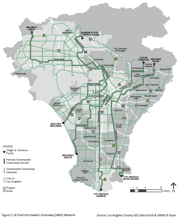
Grass I and II (2013, 2018), Cal Poly Pomona 606 Studio. Data-driven prioritization of a green infrastructure network in the Upper Los Angeles River Watershed to maximize regional social, economic, and environmental benefits. Grass II calls these “stormwater tributaries.” “There is no other city where developing a targed urban arterial stormwater management system has greater potential than in Los Angeles.” (VI) Grass II supplements GIS with Participatory Urban Assessment.
Green Visions Plan (2004-2009), University of Southern California, Rivers and Mountains Conservancy, Santa Monica Mountains Conservancy, Coastal Conservancy, and Baldwin Hills Conservancy. The Green Visions Plan is a suite of white papers aimed at integrating habitat conservation, watershed health, and recreational opportunities in Ventura, Los Angeles, and Orange Counties in to a “living green matrix for Southern California.” The plan suggests directions for integrating recreational needs with habitat opportunities and benefits to water supply and water quality. Phase II of the plan was projected to include assessment of General Plan conformance for cities and unincorporated areas, critical places assessment and pilot project sites, model ordinances for ecosystem enhancement. The Stream Assessment portion points out increase of flood peak discharge after as a result of heavy development (>80% impervious) in the Compton Creek watershed. Analytic Framework provides for a regional green network, but also provides for habitat considerations in the highly developed urban matrix, such as targeting native species (native birds and butterflies) that can become resident in fragmented small urban habitats.
Placeworks GreenScore is a proprietary system for assessment of multiple indicators for use in planning. Indicators include land use metrics such as residential and employment density, land use mix, housing affordability, infill potential, to other metrics of economics, walkability, public safety, demographics and equity. Indicators can be tailored to and prioritized to community needs, so that stakeholders can test out alternative planning scenarios.
TPL Climate Smart Cities is a toolkit for the prioritization of green infrastructure, that includes a “decision support mapping tool” which allows user to adjust the weight of different data sets to see how different prioritizations lead to diferent results. Data is grouped into the following broad themes: Connect (carbon-free mobility), Cool (using green infrastructure to reduce heat island effect and associated energy use, Absorb (prioritizing locations where water can recharge local supplies), and Protect (green infrastructure to protect from flooding and sea level rise). This tool offers means to integrate multiple benefits, with local needs, and local capacity.
Several data products created by Environmental Protection Agency summarize data about land use, urban form, and transit accessibility of neighborhoods, intended to be used for planning of walkable and transit-accessible communities. Smart Location Database (2013) is a resource for measuring “location efficiency”scores areas based on variables taken from literature on mobility and urban planning, summarized by the EPA-funded paper, Travel and the Built Environment (Ewing and Cervero, 2010). Walkability Index (2015) is a related but later product by EPA. The data is generalized within census block group.
Though Walkscore and Choicemaps are tools that were created and presented to promote real estate, such data products can be used for a different purpose: to compare why neighborhoods have different walkscores, and to bring the benefits of walkability to neighborhoods that do not currently have such benefits. Walkscore assigns communities walkability (and bikeability) scores based on computer analysis of land use attributes such as pedestrian friendliness, population density, block length, intersection density. Rankings of cities and neighborhoods are created using a grid of 500 ft. Choicemaps is a related product, ranking neighborhoods by how many errands are likely to be able to be accomplished on foot. We suggest that these real estate products be used for a different purpose than intended: some Gateway Cities neighborhoods with particularly low Walkscore and Choicemaps rankings may reap environmental and public health benefits from green infrastructure projects that promote clean air and walkability.
Toolkit resources
Metro Green Places is an online toolkit that is meant to help inspire communities to reinvent local public spaces in ways that improve the experience of users of public transportation.
Gateway Cities Council of Governments Climate Action Framework is a metrics-based decision support tool by which city planners and staff can see how different management priorities can have a direct impact on Greenhouse Gas production and climate change goals.
Future Steps
Dialogue with users will aid in further refinement of this website and its content, based on what is most valuable to users.
ws emerald necklace poster sm

Made with ❤️ by TreeStack.io
